
C-DRONE GUIDE · 25 JULY 2026
Landslide monitoring by drone: photogrammetry, risk plans, price
A moving slope does not always announce itself with a spectacular collapse: most often it is slow creep — a few centimetres a month — that cracks a road surface, deforms a railway line or threatens a quarry face long before any sudden failure. Monitoring it from the ground requires survey markers, inclinometers or extensometers installed point by point, expensive to densify across a large slope. Drones change the scale of the problem: a photogrammetric flight repeated over time produces a full 3D model of the slope, comparable from one survey to the next to within a centimetre, without a technician having to venture onto ground that is moving. Here is how drone landslide monitoring works, the regulatory framework it sits in, and what it costs in 2026.
Get up to 3 quotes from professional drone pilots in your area
Describe the mission in two steps. With your consent, it is passed on to partner professional pilots (3 at most), who contact you directly with their proposal.
Published on 25 July 2026, updated on 22 September 2026 — regulations in force as of September 2026.
Displacement shows up in the difference between two 3D models
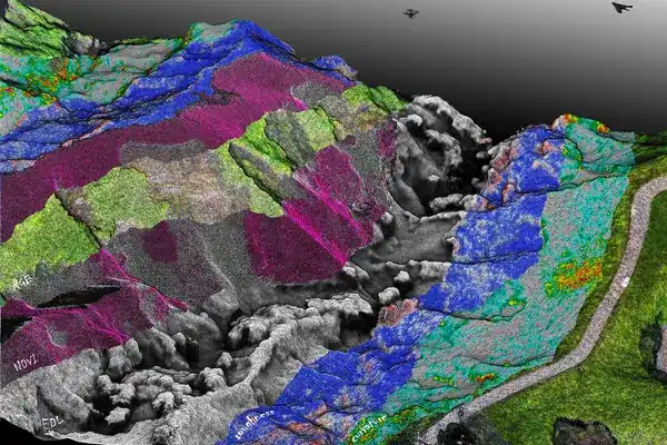
The principle is the same as for any photogrammetry: a grid of photos with heavy overlap, processed with structure-from-motion software, produces a point cloud and then a digital surface model of the slope. Flown identically a few weeks or months later, a second model is registered against the first, and the difference between the two — computed point by point — yields a ground-displacement map: stable areas in green, moving areas coloured by the amplitude and direction of the slide. Tension cracks at the top of the slope, compression bulges at the toe, and leaning or uprooted trees stand out clearly on the associated orthophoto.
The method is not new: it was validated as early as 2012 by a University of Stuttgart team (Niethammer, James, Rothmund, Travelletti and Joswig), who used a drone to monitor the Super-Sauze landslide in the southern French Alps and published their results in the journal Engineering Geology. The authors show that a mini quadrotor drone produces orthomosaics and high-resolution terrain models accurate enough to estimate the moving mass's displacement velocity and track crack widening, with a standard deviation of around 30 cm between two surveys (see the study). More than ten years on, the same principles apply with drones and software that are far more accessible.
Road cuttings, railways, quarries: who needs this monitoring
Three types of client come up most often. Road and rail network operators (regional road authorities, county councils, national rail infrastructure managers) monitor the slopes overlooking their infrastructure: a slope sliding toward a road or a railway line forces a preventive closure, and regular drone monitoring lets that closure be anticipated rather than suffered after the fact. Local authorities exposed to ground movement (built-up hillsides, old underground quarries, clay-rich areas) fold it into their natural risk prevention plan — a framework close to the one for shoreline retreat detailed in our guide on coastal erosion monitoring by drone, comparable method and monitoring logic on different terrain. Quarry operators, finally, monitor the stability of their working faces under their mining risk prevention plan — a use case close to the one described in our guide on quarry face inspection by drone, where the same technique serves site safety rather than diffuse natural-hazard prevention.
In all three cases, the drone's value lies in repeatability: a single survey gives a snapshot at one point in time, but it is the comparison across several campaigns — monthly during a crisis phase, quarterly or half-yearly for routine monitoring — that reveals an acceleration of the movement, a far more useful warning signal than a one-off measurement.
Often simple on the regulatory side, sometimes tricky to access on the ground
An unstable slope is usually located outside densely populated areas: the flight generally falls under the open category, sub-category A2 or A3, with no particular formality beyond operator registration on AlphaTango, suitable professional liability insurance and a check of restricted zones. Many unstable slopes, however, sit in mountain terrain, sometimes within a national park core zone — a combination worth checking in advance with our guide on flying a drone in the mountains and in national parks, which can require a separate access authorisation on top of flight authorisation.
The real difficulty lies elsewhere: the terrain itself. A steep slope demands an adapted flight plan (safe take-off and landing points, clearance from obstacles and vegetation, extra caution in valley winds) and enough registration accuracy that the measured differences reflect real ground movement rather than flight imprecision. For displacements of a few centimetres, ground control points or an RTK/PPK drone often become necessary — the same centimetre-level precision required for monitoring embankment settlement, described in our guide on dam and levee inspection.
The price of drone landslide monitoring in 2026
The price mainly depends on the slope's surface area, the precision required and how often campaigns run. Orders of magnitude observed in France in 2026:
| Service | Observed price (excl. VAT) |
|---|---|
| Initial slope survey (a few hectares, baseline 3D model) | €800 to €1,800 |
| Comparison campaign (registered against the baseline, displacement map) | €500 to €1,200 |
| RTK/PPK follow-up with ground control points (centimetre precision) | +€300 to €800 per campaign |
| Annual programme for an infrastructure operator (3 to 4 visits) | €3,000 to €8,000/year |
| Emergency response after a reported acceleration | premium rate, within 48 to 72 hours depending on availability |
Set against the cost of an unanticipated road closure, a derailment avoided, or a quarry face giving way, drone monitoring remains a marginal line in an infrastructure's maintenance budget. To put these amounts in context among other services, see our guide how much a drone service costs.
Frequently asked questions about drone landslide monitoring
Does the drone replace inclinometers and extensometers? No: those sensors measure continuously and at depth, whereas the drone gives a surface snapshot at each pass. The two are complementary — the drone covers the whole slope, the point sensors refine the measurement at critical spots.
What accuracy can be expected on the measured displacement? Without ground control, the standard deviation commonly sits between 10 and 30 cm depending on flight conditions; with control points or an RTK/PPK drone, accuracy drops to the centimetre.
How often should flights be flown? Quarterly to half-yearly for routine monitoring; monthly, or even tighter, as soon as a first pass reveals an acceleration of the movement.
Does a wooded slope cause a problem? Vegetation hides part of the ground — an airborne LiDAR, which penetrates forest cover, then complements classic photogrammetry where it only sees the canopy.
Put it into practice
- Drone surveying & photogrammetry: rates and cities covered from €800
- Drone security & surveillance: rates and cities covered from €600
- Surveying & photogrammetry in Cholet Pays de la Loire
- Surveying & photogrammetry in Albi Occitanie
- Surveying & photogrammetry in Carcassonne Occitanie