A professional drone pilot for this mission Request a free quote
C-DRONE GUIDE · 20 AUGUST 2026
Drone photo and video for a property listing: value, method and prices (excl. VAT)
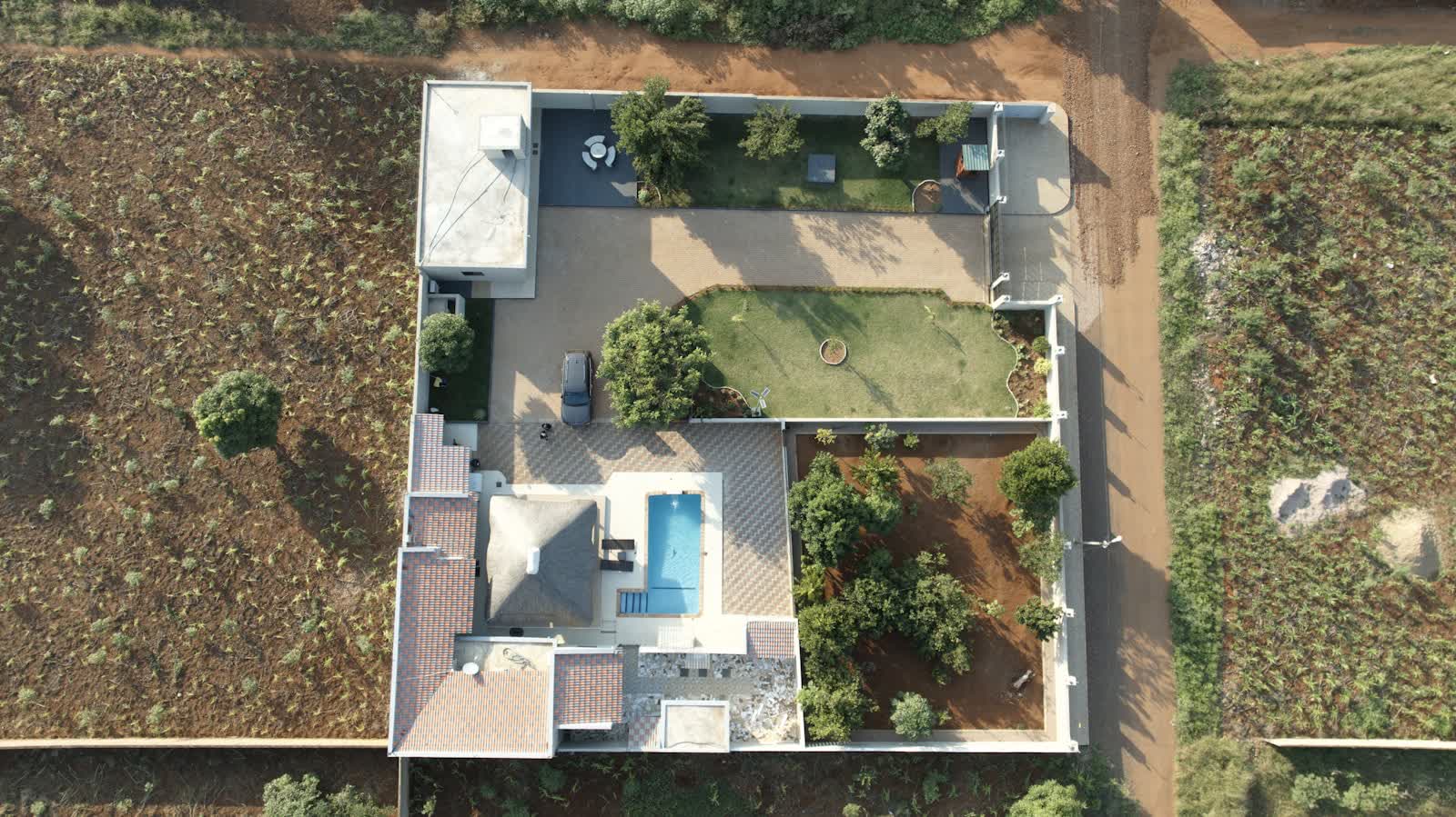
A buyer sifts through viewings from a listing's photos, long before pushing open a door. Yet a photo taken from the pavement says almost nothing about what is actually for sale: the plot's footprint, the garden's orientation, the overlooking, the closeness of the sea or the forest, a building's massing. Drones make visible everything the ground hides, and this has become a listing-pitch argument for agencies and networks of property agents. Here is what the aerial view really changes for a listing, how a shoot unfolds, what the 2026 regulations allow, and the observed prices (excl. VAT).
Published on 20 August 2026, updated on 22 September 2026 — regulations in force as of September 2026.
What the aerial view changes for a listing
The decision to view a property is made in seconds, from a thumbnail and a handful of photos. A shot from the pavement shows a facade and a strip of sky; it stays silent on most of what makes a property valuable: the plot's real area, the garden's orientation and sun exposure, the presence of a pool, the overlooking or lack of it, the distance to the forest, the water, the town centre. The aerial view, by contrast, places the property back into its surroundings and answers at a glance the questions a buyer asks before even picking up the phone.
This effect is not just a salesperson's hunch. A study by Justin Benefield, Christopher Cain and Ken Johnson published in 2011 in the Journal of Real Estate Finance and Economics, based on the listings of an MLS system, measured that the number of photographs influences the sale price: each additional exterior photo was associated with a price rise of around 1.9%, a markedly stronger effect than that of interior photos (see the study). Exterior views - precisely what a drone produces best - are therefore the ones that weigh most on the perception of value.
For an agency or a network of agents, the stake goes beyond the single listing: offering an aerial shoot becomes a listing-pitch argument. Faced with a seller torn between two firms, the promise of professional aerial presentation - where the competitor makes do with smartphone photos - often makes the difference. It is a modest marketing investment against the commission at stake, and a signal of seriousness sent to seller and buyer alike.
Locate, showcase, tell a story: the shooting method
A good real-estate drone shoot is not just "go high and press the shutter". It combines three registers. First locate: a 45° plunging view and an overhead footprint view show the plot, its boundaries, the building's siting and the access points - decisive for a house with a garden or an estate. Then showcase: close passes along facades and roof, in the grazing light of morning or late afternoon, give the building relief. Finally tell a story: a short video shot that starts on the property and rises to reveal the surroundings (sea, vineyard, village) creates the emotion that triggers a viewing request.
The type of property dictates the treatment. A house with land or an estate gets the most out of drone aerial photography and an aerial video flying over the grounds. A block or a condominium benefit from a location view showing exposure and neighbourhood. For business premises, warehouses and land, the dedicated real-estate drone service and our guide to the commercial real-estate drone detail the framing investors expect. Developers and the marketing of new-build programmes often combine aerial shooting with drone construction monitoring to illustrate progress and how the project sits in its setting.
On deliverables, the use dictates the format: high-definition JPEGs for listing portals (agency sites and property marketplaces), a short vertical format for social media, and usage rights matched to the distribution. The role of online presentation in a listing's performance is, moreover, increasingly well documented: a study published in 2024 in the Journal of Real Estate Finance and Economics on the impact of virtual marketing strategies showed that remote-presentation tools alter the relationship between price and time-on-market - one more reason to get the aerial visuals right.
The 2026 legal framework: flights, declaration and image rights
The reform in force since 1 January 2026, carried by the "Espace" order of 23 December 2025, has changed the game for city real-estate photography. Flying over built-up areas is now allowed in the open category within the professional activity of a declared operator, subject to a prior declaration to the authorities with a lead time of around ten working days. The following remain mandatory: the ban on overflying uninvolved people, a maximum height of 120 metres, and respect for restricted zones checked on the Géoportail drone map. Leisure flying, conversely, stays prohibited over urban public space: photographing a property in town is therefore a professional service, not a favour from a relative who owns a drone.
The image rights of the property itself are more favourable than commonly believed. Since a 2004 ruling of the French Cour de cassation, the owner of a property holds no exclusive right over the image of that property; they can oppose its use only by proving an abnormal nuisance. In a sale mandate, the question does not arise anyway: it is the seller who commissions the showcasing of their own property. Vigilance lies elsewhere, in the privacy of third parties.
In practice, the shoot must focus on the property for sale and avoid capturing the privacy of neighbouring properties (the inside of adjoining gardens, terraces, openings). Any identifiable person or element that appears - a face, a number plate - must be blurred: this is required both by the right to privacy (article 9 of the civil code, article 226-1 of the criminal code, which punishes with one year's imprisonment and a €45,000 fine the capture of a person's image in a private place without consent) and by the GDPR as soon as personal data is identifiable. A professional remote pilot builds these constraints into the framing: that is exactly what sets a regulated service apart from an improvised flight.
Prices observed in 2026 (excl. VAT) and how to order
The ranges observed in France in 2026 for a real-estate drone service, excl. VAT:
| Service | Observed price (excl. VAT) |
|---|---|
| Aerial photo shoot only (house, plot - one visit) | €250 to €600 |
| Photo + short edited video pack for social media and portals | €500 to €1,200 |
| Estate, grounds or new-build programme (extended flight, storytelling video) | €1,000 to €3,000 |
| Recurring agency / network package (per property, on volume) | on quote, discounted |
The price spread mostly reflects the property's extent, the local airspace constraint (a city centre under a restricted zone needs more preparation than a house on the outskirts), the volume of deliverables and whether an edited video is included - never flight time alone. For an agency, the real economic lever is the recurring package: by contracting a volume of mandates with a remote pilot, you secure a reduced unit price, short lead times and a consistent look that becomes the firm's visual signature.
A well-scoped quote states the address and municipality (to qualify the airspace constraint and the declaration lead time), the type of property, the intended use (listing portal, social media, sales brochure), the expected deliverables and the extent of the usage-rights transfer. To go further on neighbouring uses, our guides on the drone for property diagnosticians and on real-estate due diligence by drone complement the marketing side with the technical one. The simplest way to launch a mission is to request a quote stating the municipality, the type of property and the communication goal: the remote pilot qualifies the regulatory feasibility and proposes the right format.
Frequently asked questions
Can you photograph a house by drone in the middle of a city?
Yes, in a professional setting. Since 1 January 2026, flying over built-up areas is allowed in the open category for the professional activity of a declared drone operator, subject to a prior declaration and a lead time of around ten working days. The flight remains bound by the ban on overflying uninvolved people and a maximum height of 120 metres. Leisure flying, by contrast, stays prohibited over urban public space.
Do you need the neighbours' consent to photograph a property by drone?
No: a compliant flight carried out at a distance does not require the neighbours' consent, but the shot must not capture the privacy of neighbouring properties: you frame on the property for sale, avoid diving into adjoining gardens and blur where needed any identifiable person or element (number plate, face). This flows from the right to privacy (article 9 of the French civil code, article 226-1 of the criminal code) and from the GDPR as soon as a person is identifiable.
How long between the flight and delivery of the visuals?
For a standard real-estate shoot, allow 48 to 72 hours after the flight to receive the edited photos, and a little more for an edited video. An agency handling a steady flow of mandates has every interest in signing a recurring package with a remote pilot, to secure short lead times and a consistent look across all its listings.
Put it into practice
- Drone real estate drone services: rates and cities covered from €250
- Drone aerial video: rates and cities covered from €500
- Real estate drone services in Saint-Maur-des-Fossés Île-de-France
- Real estate drone services in Calais Hauts-de-France
- Real estate drone services in Chambéry Auvergne-Rhône-Alpes